We stayed a few nights in Katherine on our way to Darwin and saw most of the sites, but when we found out that the local rodeo was on the following weekend, we decided to stay for the week.


 |
| Bitter Springs is in a very quiet bush setting and a lot more room to get away from the crowd |
 |
| Mataranka Hot Springs has beautiful clear water but we found it very crowded |


 |
| Daly Waters Pub |
 |
| Daly Waters Service Station |
 |
| In the bar of the Daly Waters pub |
 |
| Entertainment in the beer garden at Daly Waters pub |

 |
| Pool at Renner Springs |
 |
| Three Ways Roadhouse mural north of Tennant Creek |
Tennant Creek, which is the 5th largest town in the Northern Territory was a welcome relief from all the goings on of the previous night, but for us there wasn’t a lot of interest.
The Overland Telegraph line which was completed in 1872, put the town on the map and now has a collection of historic stone buildings that functioned to support workers and maintenance on the line.
 Gold was also discovered in the region and the 12 stamp battery and some old mining equipment are on display at the visitor information centre. We also saw the biggest display of flowering Sturt Desert Pea growing around Lake Mary Ann which is a man-made lake only 5 kilometres north of the town, purpose built to help soften the harsh outback conditions of the area.
 The trip south from Tennant Creek is a gradual 300 metre uphill climb all the way to the top of the Davenport Ranges about 350 kilometres away. Wouldn’t you know it, we had a howling side wind for 2 days while we tackled this part of our trip, which shot our fuel consumption up to 28.9 litres per hundred kilometres. This could only happen in the most expensive place on our journey with fuel being at $2.12 per litre at our next stop.
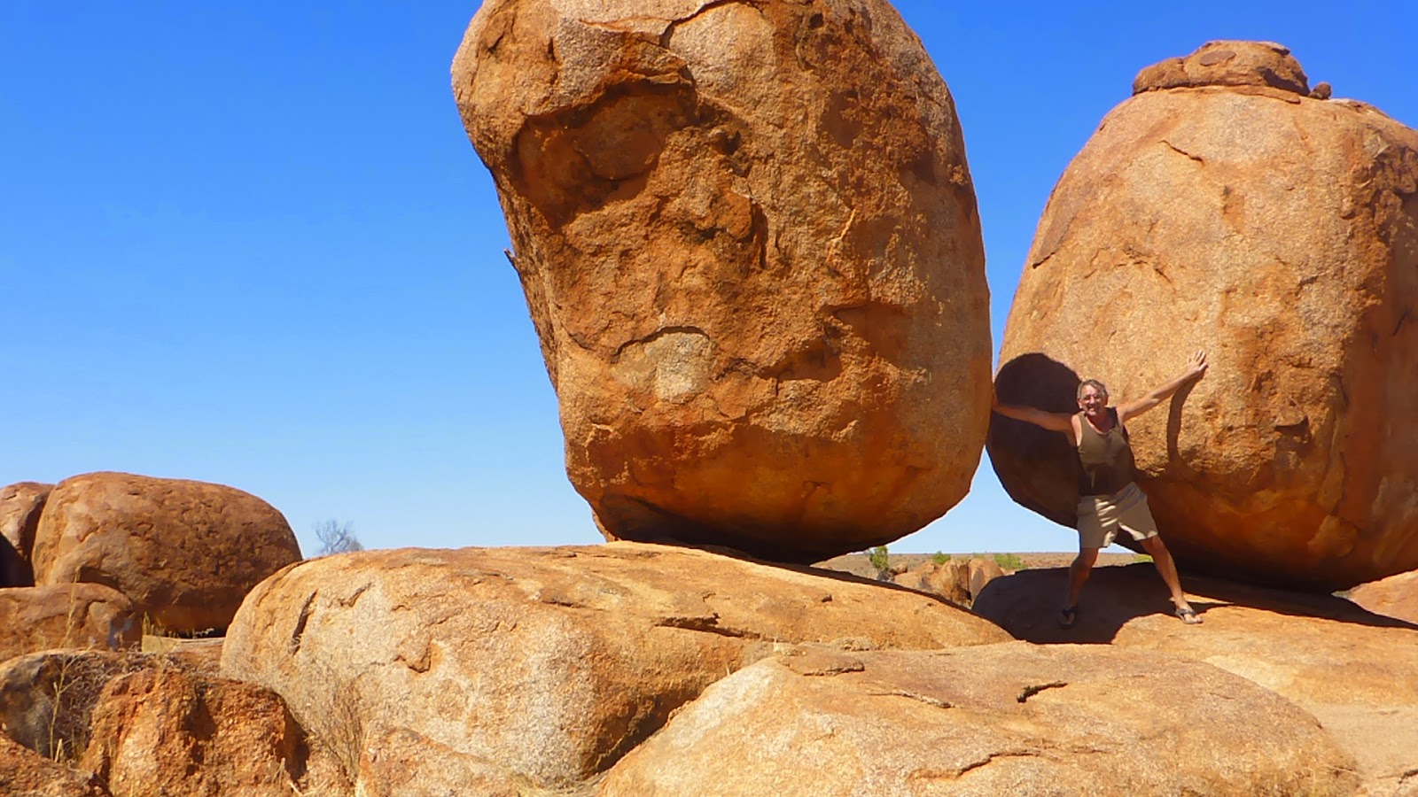 Along the way we came across an area about 1,820 hectares in size, that is covered with unusual rock formations called “The Devils Marbles”, or Karlu Karlu as they are known by the local Warumungu Aboriginals. This a collection of huge, red, rounded granite boulders that vary in size from 50 cm up to six metres across, and they are strewn right across a area. Many of them seem impossibly balanced on top of each other, just like the two marbles in the picture above .
 The Devils Marbles started out, many million years ago, when an upsurge of molten rock reached the surface, spread out and settled into a solid layer. That one block of granite then developed horizontal and vertical cracks and split into many rectangular blocks. Over the following millions of years, erosion did what it always does and wore away the edges. You can see the later stages of that process on rocks all across the reserve. Some parts still hint at the original rectangular shapes while some blocks have their corners worn of and some are totally rounded. Every marble looks different. You can walk around for ages and find new and interesting views at every turn.
 Wycliffe Well, which is known as Australia’s UFO capital due to the hundreds of UFO sightings that have occurred there since WWII, was a good overnight stop to get out of the wind. What an awesome little place, miles from nowhere, but with great hospitality and clean amenities and ablution blocks. They really take the UFO thing to the max with aliens and space ships all round the place. I had a good chat with the owner and he said there are good documented sightings of many UFO’s since WW2, and believes that sightings are so regular because they are situated under the crossing of the magnetic Ley Lines that UFO’s use as highways.
 He also believes that as they are right on the edge of the Tanami Desert, all the rain that falls over the north side of the Davenport Ranges seeps down through the sand and there is a huge underground lake just 30 metres below them which is about 60 kilometres in diameter. This huge expanse of water together with the magnetic Ley Lines possibly has something to do with the UFO’s navigation equipment. Hmmm, I wonder. We didn’t see any UFO’s but we only had one drink with our meal!
At last the wind had died down a bit and the down hill run off the top of the Davenport Range to Barrow Creek was much more pleasant.
 Barrow Creek was one of the original overland telegraph repeater stations built in 1872 to service the phone line that connected Australia to England. The buildings are still in good condition and now under the care of the Parks and Wildlife as Historic Reserves.
 Aileron is another of those quirky little roadhouses right alongside the Stuart Highway about 135 kilometres north of Alice Springs. As you turn into their service road the first thing that hits you in the eyes is a 17 m sculpture of Charlie Portpot up on the hill behind the roadhouse.
 Charlie was the local rainmaker who lived around this area over 100 years ago with his wife Matilda and their children. The statue of Matilda with one of their children and a large goanna beside the aboriginal arts centre is just as imposing.
 |
| Love the outback humor |
What better place for an overnight stop with friendly staff and excellent meals in the pub.
 |
| Tropic of Capricorn marker |
About 30 kilometres north of Alice Springs, we crossed back over the Tropic of Capricorn which is the marker between the “tropical” zone and the “temperate” zone, even though the monsoonal weather pattern peters out about 800 kilometres north of here at Newcastle Water.
Another 10 kilometres on further south we found the reason why we had used so much fuel since we left Mataranka.
 |
| Cairn marking the highest point on the highway between Darwin and Adelaide |
Here is the marker for the highest point on the Stuart Highway which is 727 metres above sea level, so we have been gradually climbing for the last 1,000 kilometres, but now it should be all down hill from here back to Adelaide.
We visited Alice Springs briefly back in 2006 and it sure has grown a lot since then. Now it has traffic lights, new caravan parks and a whole new shopping plaza.
No comments:
Post a Comment