
As Kununurra was only gazetted in 1961, it is one of the youngest towns in Western Australia which was developed through the construction of the Ord Irrigation Scheme.
 The Diversion Dam which was the first stage in the construction of the scheme comprises of 20 radial gates that are raised or lowered to regulate the water level in Lake Kununurra, primarily to maintain water flow to the irrigation area and also to manage wet season flood levels. This dam wall which was completed in 1963 also forms part of the Victoria Highway at the west side of the town. Unfortunately the Ord River Irrigation Scheme has had a number of spectacular failures, pushed by successive governments. First was the cotton crop from 1963 to 1974. The high number of pests meant the cotton had to be sprayed every two to four days, a massive use of millions of litres of pesticides, which made it nonviable so it was eventually abandoned. Next to come were peanuts and rice. The rice crop attracted 8000 to 10,000 magpie geese an hour which meant the airport became unmanageable and eventually rice was also abandoned. The growth of vegetables has been successful and many are still grown today, subject to massive irrigation from the Ord River.
 On our approach into the town we noticed what appeared to be tree plantations with 3 or 4 different species of trees all planted in consecutive rows. We found out during our look around town that these are Indian Sandalwood plantations. The reason for the different species of trees all in the same plantation is that Sandalwood has a poorly developed root system and is classified as a hemi-parasite, due to its inability to fix nitrogen in the soil. It therefore needs other trees and legumes to grow around it for it to grow and survive. Sandalwood has been an integral part of Asian culture and religion for thousands of years, and remains a key ingredient in leading fragrances and cosmetics. Sandalwood features in incense, perfume, carvings, medicines, fashion, furnishings and religious ceremonies around the globe. The Indian species of Sandalwood commands the highest price at auction due to its superior oil yields and long-term market acceptance. The price of wild Indian Sandalwood sold at auctions in Indian has continued to increase over the last 20 years with the price for Indian Sandalwood logs averaging over A$100,000 per tonne. The unique climate of Australia’s tropical north provides an ideal location for the growth of Indian Sandalwood. It was first planted in Kununurra in 1999 and a further 7,500 hectares of commercial Indian Sandalwood have been planted since. Sandalwood plantations in Western Australia are assisting to lower the watertable and reduce salinity problems across the Ord River Irrigation Area (ORIA). The bio-diverse nature of Sandalwood plantations also makes them an ideal nesting place for native birds. As with any large scale farming operation, there are always pros and cons. Of course the Sandalwood growers are very positive and predicting excellent returns over 20 years, but the skeptics say that this area should be kept as a food bowl producing fruit and vegetables.
 Another new crop being grown around the area is a little known ancient seed that has emerged as the most lucrative crop option for Stage 2 of the State and Federal Government's $415 million investment in the Ord River Irrigation Development project. The chia plant, first used by the Aztecs, produces a tiny seed that is the richest plant source combining Omega 3, dietary fibre, protein and antioxidants, making it the most nutritional grain available and therefore contributing to a healthy global community. Growing chia is very latitude specific, it has to be grown in the range 15-20 degrees north or south of the Equator to optimise the Omega 3 ratio in the oil. Chia needs to be grown during the dry season as the seed is hydrophilic meaning that it is covered by a microscopic fibre that turns to gel when it comes in contact with water. The gelling is one of the key nutritional and functional benefits of chia, but if chia gets rain on it, it will ruin the crop. It is interesting to see how these new crops develop and the chia harvest is said to be worth $20 million by 2015. As we travel around, we are always amazed at the amount of different things that we find that are said to be unique to that particular area.
 Zebra Stone is another one of these things which is only found near Kununurra in the Kimberley Region of Western Australia. This is a rare and beautiful stone said to be formed long before animal life moved about earth. The totally unique Zebra Stone has been estimated to be 600 million years old and the only deposits in the world have been discovered right here, just east of Kununurra. It consists of a fine grained siliceous argillite with rhythmic patterns of red bands or spots contrasting sharply with a lighter background. It is not known how the regular patterns were formed but the red stripes are coloured ferric (iron) oxide. Geologists have investigated Zebra Stone without producing any valid explanation of its origin. The rock's natural beauty typifies the colours and spirit of Australia and some have said that the stone has a special quality for bringing luck. There are 3 or 4 galleries around town that work with this stone and make some beautiful sculptures.
 We were lucky enough to pick up this beautiful little partly finished crocodile straight from the workshop at a fraction of the finished price. All I need to do is give him a good clean up with wet and dry sandpaper and then a couple of coats of clear varnish to make the colours stand out.
We weren't going to visit Wyndham but after finding some advertising on Parry Creek Farm we decided that it would be worth back tracking a bit and we weren't disappointed.
 We stayed at the Parry Creek Farm right near the Marlgu Billabong in Parry Creek Reserve which is a natural habitat for hundreds of birds and the odd fresh water crocodile or two. They have built a walkway out beside the lagoon with a bird watching hide at the end. While we were standing there a crocodile swam stealthly under the water right below to where we were standing in the bird hide.
 We could see bubbles coming up but couldn’t see him. He surfaced briefly right in front of us after about 10 minutes and we could plainly see that he was about 2.5 metres long. He must have decided that it would be too hard to get to us so off he went. Just goes to show how easily you could get attacked if you were standing by the waters edge.
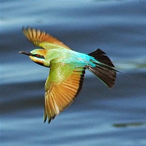 We spotted a rare Rainbow Bee Eater.What a beautiful bird but my photos turned out poorly so I grabbed one off the internet. Wyndham is the Kimberley's oldest town, Western Australia's northernmost town, and it's also Australia's hottest town. Marble Bar might claim the highest peak temperatures, but Wyndham has the highest year round average temperature.
 The first thing you see when entering the town is the giant crocodile which was built by a group of students back in 1980. She is made up of 55 kilometres of steel rod, 50 kilograms of welding rods, 10 rolls of bird mesh and 5 cubic metres of concrete. Wyndham has a lot of history going back to the 1880’s which was first sparked by the gold rush, followed by supporting the pastoral industry with a thriving meat industry as well as imports and exports from the wharf. The Port of Wyndham was an integral link with the outside world and supported the whole of the East Kimberly region. Camel, bullock and donkey teams were vital for the transportation of goods from the port to outlying stations as far afield as Halls Creek.(375 kilometres by todays roads).
 Now days the biggest thing that happens in town is the export of iron ore from the Ridges mine which is 165 kilometres south west of Wyndham. 38 road trains travel down to the mine each day and bring 150,000 tonnes of Iron ore fines in 110 tonne loads back to the port each month. As the port is on the river it is not deep enough for ships to come in, so the iron ore is loaded onto barges and towed out to the waiting ships anchored in the Cambridge Gulf. A 65,000 tonne ship is loaded every 2 weeks with a tug towing 2 or 3 barges transferring iron ore to the ship.
 The wharf and surrounding area can be seen from the Five Rivers lookout on top of the Bastion Range which is 350 metres above sea level. The Forest, Pentecost, Durack, King and Ord rivers all enter the Cambridge Gulf at Wyndham.
 A proud monument to the indigenous heritage is on display at Warriu Park where the Dreamtime Statues can be seen depicting early aboriginal life at Wyndham. The Statues were built as part of a Bi-Centenary project and originally intended for Kings Park in Perth as an Indigenous People contribution towards Reconciliation and the development of a new Australian society.
 One of WA’s best kept secrets is the caravan park at Lake Argyle.This place has one of the best infinity swimming pools with one of the best backdrops you could ever find anywhere.The caravan park is tree to tree grass as you would imagine with all that water available.
 It is a real resort style caravan park with a bar and restaurant right on the site that serve beautiful meals at very reasonable prices in a beautiful outdoor setting. Lake Argyle is the water supply for the Ord River scheme at Kununurra. It is Australia’s largest expanse of freshwater covering an area of more than 900 square kilometres at full supply level and up to 2000 square kilometres when in flood. At full supply level it holds 21 times more water than Sydney Harbour.
 We took a cruise on an unusual boat called the Kimberly Durack which is named after the grazier whose family moved into this area from central Queensland in the early 1800’s. Kimberly had a vision for the Ord River scheme at Kununurra as well as the lake to supply the water. It was their property that was flooded when the dam wall was completed to make the lake. Ironically, Kimberly died in 1968 just as the dam was starting to be built.
 The dam wall which is only 334 metres long has been built across the Ord River between 2 solid rock walls. The wall is 67.5 metres above the original river level and it was constructed using 1,522,306 cubic metres of rock fill and 243,111 cubic metres of impervious clay as a core to give the wall some flexibility. The rock for the wall was blown out of a mountain only about 2 kilometres away from the wall site. The first blast shattered just under 1 million tonnes of rock and the second blast the following year blew out just over 1 million tonnes of rock. This is still the biggest single blast undertaken in Australia to this day. The blast registered 5.4 on the Richter scale all the way across the country in Sydney. It is believed that if this wall was to fail, it would only take 15 minutes to flood Kununurra which is 35 kilometres away by river. It would also then take 4 years for the lake to completely empty. When the dam wall was completed in 1973, it was expected that it would take 8 wet seasons to fill the lake but it was filled in less than 3 years, which left a lot of the Durack station buildings go under water.
 Fortunately they were able to pull down the original homestead and relocate it to higher ground at a later stage. The house is now a wonderful museum to the Durack family and the early years in the Kimberly.
The cruise took us about 7 kilometres down the lake and around a lot of the many islands that the water created and out into the big section of the lake. This gave us a better idea of the size of the lake as 35 kilometres off to the east was the edge of the lake near the Northern Territory border and 55 kilometres to the south is the Argyle Diamond Mine along the southern edge of the lake.
 One of the highlights of the tour was a swim in the lake at sunset with a wine , soft drink or ice cold beer. The boat anchored in 32 metres of water and in we went for a cooling swim. What a great place to swim and watch the sun go down for the evening.
 Now days there is a 30 megawatt hydro power station at the bottom of the wall which supplies power to Kununurra, Wyndham and Argyle Diamond Mine. This little power station replaces diesel power stations which used to burn 60 million litres of diesel annually.
We moved from the West Kimberly to the east and kept thinking that the Pilbra region further south was better, but after continuing on our way east. we have found just as many awe inspiring sites along the way.
 |
| I cant resist taking a photo of a boab tree at sunset |
No comments:
Post a Comment